Early detection of biomass production deficit hot-spots in semi-arid environment using FAPAR time series and a probabilistic approach
Abstract
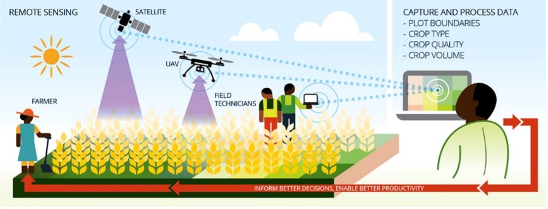
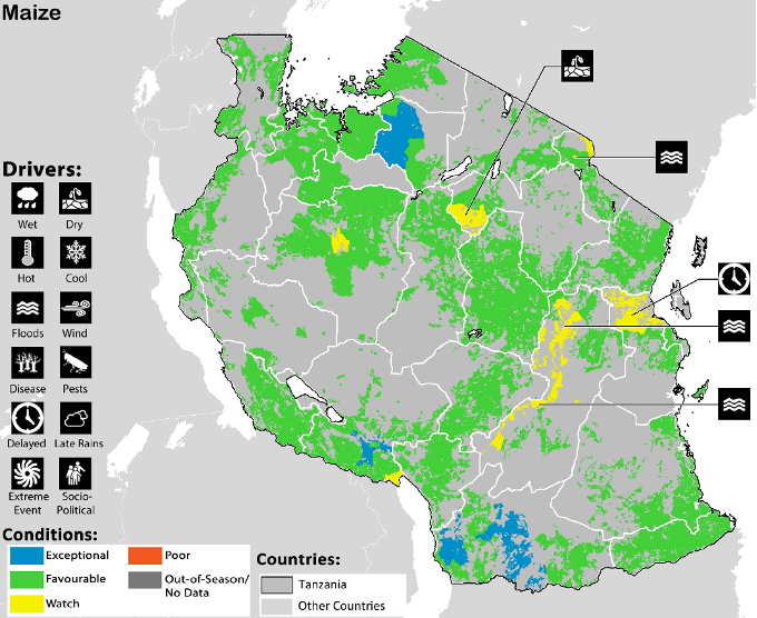
Early warning monitoring systems in food-insecure countries aim to detect unfavourable crop and pasture conditions as early as possible during the growing season. This manuscript describes a procedure to estimate the probability of experiencing an end-of-season biomass production deficit during the on-going season based on a statistical analysis of Earth Observation data. A 15-year time series of the Fraction of Absorbed Photosynthetically Active Radiation from the SPOT-VEGETATION instrument is used to characterize the climatological development of vegetation, its variability and its current status. Forecasts of overall seasonal performances, expressed in terms of the probability of experiencing a critical deficit at the end of the growing season, are updated regularly whenever a new satellite observation is made available. Results and performances of the method are discussed for croplands and pastures in the Sahel.
Related pages
-
Crop Monitoring Based on SPOT-5 Take-5 and Sentinel-1A Data for the Estimation of Crop Water Requirements
Author: Navarro, Ana and Rolim, João and Miguel, Irina and Catalão, João and Silva, Joel and Painho, Marco and Vekerdy, Zoltán -
Quantifying Fertilizer Application Response Variability with VHR Satellite NDVI Time Series in a Rainfed Smallholder Cropping System of Mali
Author: Blaes, Xavier and Chomé, Guillaume and Lambert, Marie-Julie and Traoré, Pierre Sibiry and Schut, Antonius G. T. and Defourny, Pierre -
THE COMBINATION OF UAV SURVEY AND LANDSAT IMAGERY FOR MONITORING OF CROP VIGOR IN PRECISION AGRICULTURE
Author: Lukas, V. and Novák, J. and Neudert, L. and Svobodova, I. and Rodriguez-Moreno, F. and Edrees, M. and Kren, J. -
A Framework for Defining Spatially Explicit Earth Observation Requirements for a Global Agricultural Monitoring Initiative (GEOGLAM)
Author: Whitcraft, Alyssa and Becker-Reshef, Inbal and Justice, Christopher -
Aridity level, rainfall pattern and soil features as key factors in germination strategies in salt-affected plant communities
Author: Estrelles, E. and Biondi, E. and Galiè, M. and Mainardi, F. and Hurtado, A. and Soriano, P. -
Comparison of biophysical and satellite predictors for wheat yield forecasting in Ukraine
Author: Kolotii, A. and Kussul, N. and Shelestov, A. and Skakun, S. and Yailymov, B. and Basarab, R. and Lavreniuk, M. and Oliinyk, T. and Ostapenko, V. -
Determinants of the spatial distribution of cultivated land in the North Argentine Dry Chaco in a multi-decadal study
Author: Gasparri, Nestor Ignacio and Grau, H. Ricardo and Sacchi, Laura Valeria -
Downscaling Satellite-Based Soil Moisture in Heterogeneous Regions Using High-Resolution Remote Sensing Products and Information Theory: A Synthetic Study
Author: Chakrabarti, Subit and Bongiovanni, Tara and Judge, Jasmeet and Nagarajan, Karthik and Principe, Jose C. -
Land Cover and Crop Type Classification along the Season Based on Biophysical Variables Retrieved from Multi-Sensor High-Resolution Time Series
Author: Waldner, François and Lambert, Marie-Julie and Li, Wenjuan and Weiss, Marie and Demarez, Valérie and Morin, David and Marais-Sicre, Claire and Hagolle, Olivier and Baret, Frédéric and Defourny, Pierre -
Mapping Priorities to Focus Cropland Mapping Activities: Fitness Assessment of Existing Global, Regional and National Cropland Maps
Author: Waldner, François and Fritz, Steffen and Di Gregorio, Antonio and Defourny, Pierre -
Relationships between primary production and crop yields in semi-arid and arid irrigated agro-ecosystems
Author: Jaafar, H. H. and Ahmad, F. A. -
Rice yield estimation using multispectral data from UAV: A preliminary experiment in northern Italy
Author: Stroppiana, Daniela and Migliazzi, Mauro and Chiarabini, Valter and Crema, Alberto and Musanti, Mauro and Franchino, Carlo and Villa, Paolo -
The Tasseled Cap Transformation for RapidEye data and the estimation of vital and senescent crop parameters
Author: Schönert, M. and Zillmann, E. and Weichelt, H. and Eitel, J.U.H. and Magney, T.S. and Lilienthal, H. and Siegmann, B. and Jarmer, T. -
Towards a satellite based system for monitoring agricultural water use: A case study for Saudi Arabia
Author: McCabe, Matthew F and Houborg, Rasmus and Rosas, Jorge and Ershadi, Ali and Anderson, Martha and Hain, Christopher -
A physically based vegetation index for improved monitoring of plant phenology
Author: Jin, Hongxiao and Eklundh, Lars -
Assessing Agricultural Vulnerability in India using NDVI Data Products
Author: Kaushalya, R. and Praveen Kumar, V. and Shubhasmita, S. -
Crop Condition Assessment with Adjusted NDVI Using the Uncropped Arable Land Ratio
Author: Zhang, Miao and Wu, Bingfang and Yu, Mingzhao and Zou, Wentao and Zheng, Yang -
Farmers' decision-making process under drought
Author: Keshavarz, Marzieh and Karami, Ezatollah -
From Remotely Sensed Vegetation Onset to Sowing Dates: Aggregating Pixel-Level Detections into Village-Level Sowing Probabilities
Author: Marinho, Eduardo and Vancutsem, Christelle and Fasbender, Dominique and Kayitakire, François and Pini, Giancarlo and Pekel, Jean-François -
Investigating the Relationship between the Inter-annual Variability of Satellite-derived Vegetation Phenology and a Proxy of Biomass Production in the Sahel
Author: Meroni, Michele and Rembold, Felix and Verstraete, Michel M. and Gommes, Rene and Schucknecht, Anne and Beye, Gora -
Landsat-8: Science and Product Vision for Terrestrial Global Change Research
Author: D.P. Roy and M.A. Wulder and T.R. Loveland and Woodcock, C.E. and R.G. Allen and M.C. Anderson and D. Helder and J.R. Irons and D.M. Johnson and R. Kennedy and T.A. Scambos and C.B. Schaaf and J.R. Schott and Y. Sheng and E.F. Vermote and A.S. Belward and -
Mapping irrigated areas in Afghanistan over the past decade using MODIS NDVI
Author: Shahriar Pervez, Md. and Budde, Michael and Rowland, James -
Operationalizing crop monitoring system for informed decision making related to food security in Nepal
Author: Qamer, F. M. and Shah, S. N. Pd. and Murthy, M. S. R. and Baidar, T. and Dhonju, K. and Hari, B. G. -
Separating Crop Species in Northeastern Ontario Using Hyperspectral Data
Author: Wilson, Jeffrey and Zhang, Chunhua and Kovacs, John -
UAV Flight Experiments Applied to the Remote Sensing of Vegetated Areas
Author: Salamí, Esther and Barrado, Cristina and Pastor, Enric -
Assessing Canopy PRI from Airborne Imagery to Map Water Stress in Maize
Author: M. Rossini and F. Fava and S. Cogliati and M. Meroni and A. Marchesi and C. Panigada and C. Giardino and L. Busetto and M. Migliavacca and S. Amaducci and R. Colombo -
Assimilation of remotely sensed soil moisture and vegetation with a crop simulation model for maize yield prediction
Author: Ines, Amor V.M. and Das, Narendra N. and Hansen, James W. and Njoku, Eni G. -
Cumulative effects of reduced tillage and mulching on soil properties under semi-arid conditions
Author: Mupangwa, W. and Twomlow, S. and Walker, S. -
Estimating Crop Coefficients Using Remote Sensing-Based Vegetation Index
Author: Kamble, Baburao and Irmak, Ayse and Hubbard, Kenneth -
Gaussian Processes Uncertainty Estimates in Experimental Sentinel-2 LAI and Leaf Chlorophyll Content Retrieval
Author: Jochem Verrelst and Juan Pablo Rivera and José Moreno and Gustavo Camps-Valls -
Investigation of Leaf Diseases and Estimation of Chlorophyll Concentration in Seven Barley Varieties Using Fluorescence and Hyperspectral Indices
Author: Yu, Kang and Leufen, Georg and Hunsche, Mauricio and Noga, Georg and Chen, Xinping and Bareth, Georg -
Mapping cropping intensity of smallholder farms: A comparison of methods using multiple sensors
Author: Jain, Meha and Mondal, Pinki and DeFries, Ruth S. and Small, Christopher and Galford, Gillian L. -
Spatial statistic to assess remote sensing acreage estimates: An analysis of sugarcane in São Paulo State, Brazil
Author: Mello, Marcio Pupin and Aguiar, Daniel Alves and Rudorff, Bernardo Friedrich Theodor and Pebesma, Edzer and Jones, Jim and Santos, Naiara Carolina Pontes -
The emerging small-scale cattle farming sector in Uzbekistan: Highly integrated with crop production but suffering from low productivity
Author: Siegmund-Schultze, M. and Rischkowsky, B. and Yuldashev, I. and Abdalniyazov, B. and Lamers, J.P.A. -
Use of high-resolution multispectral imagery from an unmanned aerial vehicle in precision agriculture
Author: Al-Arab, Manal and Torres-Rua, Alfonso and Ticlavilca, Andres and Jensen, Austin and McKee, Mac -
Web service-based vegetation condition monitoring system - VegScape
Author: Yang, Zhengwei and Yu, Genong and Di, Liping and Zhang, Bei and Han, Weiguo and Mueller, Rick -
Agriculture and Trade Opportunities for Tanzania: Past Volatility and Future Climate Change
Author: Syud Amer Ahmed and Noah S. Diffenbaugh and Thomas W. Hertel and William J. Martin -
Cereal yield response to conservation agriculture practices in drylands of West Africa: A quantitative synthesis
Author: Bayala, J. and Sileshi, G.W. and Coe, R. and Kalinganire, A. and Tchoundjeu, Z. and Sinclair, F. and Garrity, D. -
Estimation of leaf water content from far infrared (2.5–14 µm) spectra using continuous wavelet analysis
Author: Ullah, Saleem and Skidmore, Andrew K. and Naeem, Mohammad and Schlerf, Martin -
Implications of climate, land-use and land-cover changes for pastoralism in eastern Sudan
Author: Sulieman, H.M. and Elagib, N.A. -
MAPPING CROP STATUS FROM AN UNMANNED AERIAL VEHICLE FOR PRECISION AGRICULTURE APPLICATIONS
Author: Guo, T. and Kujirai, T. and Watanabe, T. -
Millet (Pennisetum typhoides) yield and selected soil attributes as influenced by some tree types of the semi-arid tropics of Sudan
Author: Mubarak, A.R. and Abdalla, M.H. and Nortcliff, S. -
The use of unmanned aerial vehicles and wireless sensor network in agricultural applications
Author: Costa, Fausto G. and Ueyama, Jo and Braun, Torsten and Pessin, Gustavo and Osorio, Fernando S. and Vargas, Patricia A. -
A continental analysis of correlations between tree patterns in African
Author: Groen, T.A. and van Langevelde, F. and van de Vijver, C.A.D.M. and de Raad, A.L. and de Leeuw, J. and Prins, H.H.T. -
Changes in soil nutrients, vegetation structure and herbaceous biomass in response to grazing in a semi-arid savanna of Ethiopia
Author: Tessema, Z.K. and de Boer, W.F. and Baars, R.M.T. and Prins, H.H.T. -
Continuity of Landsat observations: Short term considerations
Author: Wulder, Michael A. and White, Joanne C. and Masek, Jeffrey G. and Dwyer, John and Roy, David P. -
Desertification in the Sahel: Towards better accounting for ecosystem dynamics in the interpretation of remote sensing images
Author: Hein, L. and de Ridder, N. and Hiernaux, P. and Leemans, R. and de Wit, A. and Schaepman, M. -
Downscaling Pesticide Use Data to the Crop Field Level in California Using Landsat Satellite Imagery: Paraquat Case Study
Author: Maxwell, Susan K. -
High-biomass sorghum yield estimate with aerial imagery
Author: Sui, Ruixiu and Hartley, Brandon E. and Gibson, John M. and Yang, Chenghai and Thomasson, J. Alex and Searcy, Stephen W. -
High-resolution multispectral satellite image matching using scale invariant feature transform and speeded up robust features
Author: Teke, Mustafa and Vural, M. Firat and Temizel, Alptekin and Yardımcı, Yasemin -
Mapping potato crop height and leaf area index through vegetation indices using remote sensing in Cyprus
Author: Papadavid, George and Hadjimitsis, Diofantos and Toulios, Leonidas and Michaelides, Silas -
Pastoralism within the cadastral system: Seasonal interactions and access agreements between pastoralists and non-pastoralists in Northern Kenya
Author: Lengoiboni, M. and van der Molen, P. and Bregt, A.K. -
Retrieval of canopy height using moderate-resolution imaging spectroradiometer (MODIS) data
Author: Wang, Zhuosen and Schaaf, Crystal B. and Lewis, Philip and Knyazikhin, Yuri and Schull, Mitchell A. and Strahler, Alan H. and Yao, Tian and Myneni, Ranga B. and Chopping, Mark J. and Blair, Bryan J. -
Shifting farming–pastoral ecotone in China under climate and land use changes
Author: Liu, Jun-hui and Gao, Ji-xi and Lu, Shi-Hai and Han, Yong-wei and Nie, Yi-huang -
Start, end and dry spells of the growing season in semi-arid southern Zimbabwe
Author: Mupangwa, W. and Walker, S. and Twomlow, S. -
Using existing agricultural infrastructure for restoration practices: Factors influencing successful establishment of Populus fremontii over Tamarix ramosissima
Author: Bunting, D.P. and Kurc, S.A. and Grabau, M.R. -
Current Status and Future Directions of Precision Aerial Application for Site-Specific Crop Management in the USA
Author: Lan, Yubin and Thomson, Steven J. and Huang, Yanbo and Hoffmann, W. Clint and Zhang, Huihui -
Remote-Sensing Based Approach to Improve Regional Estimation of Renewable Water Resources for Sustainable Development
Author: Eugene Yan and Adam Milewski and Ahmed Abdeldayem and Farouk Soliman and Kamil Abdel Gelil -
Monitoring Maize (Zea mays L.) Phenology with Remote Sensing
Author: Viña, Andrés and Gitelson, Anatoly A. and Rundquist, Donald C. and Keydan, Galina and Leavitt, Bryan and Schepers, James -
Agricultural Partnerships take Root accross Africa; 2nd Annual Report on Private-sector Investment in Support of Country-led Transformations in African Agriculture
Author: Grow Africa Secretariat - Crop growth
- Monitoring crop growth and performance
- The biophysical environment
- The primary food production process